
Thank you for supporting this site ❤️
Make a donation
Make a donation
Ostrohe topographic map
Click on the map to display elevation.
Thank you for supporting this site ❤️
Make a donation
Make a donation
About this map
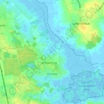
Name: Ostrohe topographic map, elevation, terrain.
Average elevation: 6 m
Minimum elevation: -4 m
Maximum elevation: 22 m
Thank you for supporting this site ❤️
Make a donation
Make a donation
Other topographic maps
Click on a map to view its topography, its elevation and its terrain.
Thank you for supporting this site ❤️
Make a donation
Make a donation
WKK Ententeich
Deutschland > Schleswig-Holstein > Dithmarschen > Heide > Hochfeld
Average elevation: 8 m
Thank you for supporting this site ❤️
Make a donation
Make a donation
Thank you for supporting this site ❤️
Make a donation
Make a donation
Zippelkoog
Deutschland > Schleswig-Holstein > Dithmarschen > Helse > Zippelkoog
Average elevation: 1 m
Thank you for supporting this site ❤️
Make a donation
Make a donation
Poppenwurth
Deutschland > Schleswig-Holstein > Dithmarschen > Oesterwurth > Poppenwurth
Average elevation: 2 m
Thank you for supporting this site ❤️
Make a donation
Make a donation
Oldörpen
Deutschland > Schleswig-Holstein > Dithmarschen > Tensbüttel-Röst > Tensbüttel > Oldörpen
Average elevation: 17 m