
Brussels–Scheldt Maritime Canal topographic map
Interactive map
Click on the map to display elevation.
About this map
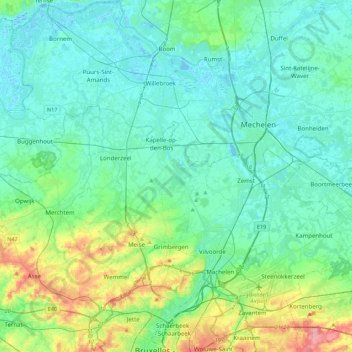
Name: Brussels–Scheldt Maritime Canal topographic map, elevation, terrain.
Average elevation: 22 m
Minimum elevation: -3 m
Maximum elevation: 110 m
The difference in altitude of 14 m between Brussels and the Rupel river at Willebroek was achieved with 4 locks. With the commissioning of the canal, the ships could now avoid navigating the Zenne and being subject to tax in Mechelen.
Other topographic maps
Click on a map to view its topography, its elevation and its terrain.
Woluwe
Belgium > Flemish Brabant > Brussels-Capital > Brussels
Woluwe, Brussels, City of Brussels, Brussels-Capital, Flemish Brabant, Brussels-Capital, 1831, Belgium
Average elevation: 64 m