
Tignes Les Brevières topographic map
Interactive map
Click on the map to display elevation.
About this map
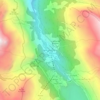
Name: Tignes Les Brevières topographic map, elevation, terrain.
Average elevation: 2,079 m
Minimum elevation: 1,448 m
Maximum elevation: 2,827 m
Other topographic maps
Click on a map to view its topography, its elevation and its terrain.
Val-Claret
Frankrijk > Auvergne-Rhône-Alpes > Savoie > Tignes > Val-Claret
Val-Claret, Tignes, Albertville, Savoie, Auvergne-Rhône-Alpes, Metropolitaans Frankrijk, 73320, Frankrijk
Average elevation: 2,409 m