
Thank you for supporting this site ❤️
Make a donation
Make a donation
Petersberg topographic map
Click on the map to display elevation.
Thank you for supporting this site ❤️
Make a donation
Make a donation
About this map
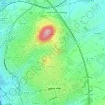
Name: Petersberg topographic map, elevation, terrain.
Location: Petersberg, Landkreis Fulda, Hessen, Deutschland (50.55151 9.69631 50.57715 9.74536)
Average elevation: 336 m
Minimum elevation: 283 m
Maximum elevation: 465 m
Thank you for supporting this site ❤️
Make a donation
Make a donation
Other topographic maps
Click on a map to view its topography, its elevation and its terrain.