
Make a donation
Santana do Cariri topographic map
Click on the map to display elevation.
Make a donation
About this map
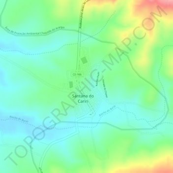
Name: Santana do Cariri topographic map, elevation, terrain.
Location: Santana do Cariri, Ceará, Northeast Region, Brazil (-7.19016 -39.74095 -7.17853 -39.73275)
Average elevation: 525 m
Minimum elevation: 485 m
Maximum elevation: 607 m
Make a donation
Other topographic maps
Click on a map to view its topography, its elevation and its terrain.
Make a donation
Guaramiranga
Guaramiranga is one of the smallest towns of the Northeastern state of Ceará in Brazil. It is located at an altitude of 865 m in the Serra de Baturité hills 110 km from the state capital of Fortaleza. Guaramiranga is known locally for its temperate climate and lush green scenery. The temperature in…
Average elevation: 676 m
Make a donation
Make a donation
Make a donation
Guaramiranga
Guaramiranga is one of the smallest towns of the Northeastern state of Ceará in Brazil. It is located at an altitude of 865 m in the Serra de Baturité hills 110 km from the state capital of Fortaleza. Guaramiranga is known locally for its temperate climate and lush green scenery. The temperature in…
Average elevation: 676 m
Make a donation
Make a donation
Crato
Crato is about 550 km from Fortaleza, the capital of the state of Ceará. Its county has a surface area of approximately 1,117 km2. It is at an altitude of 426m, 07°14′03″S 39°24′34″W / 7.23417°S 39.40944°W / -7.23417; -39.40944. Its population of 110,000 makes it the sixth-largest city in…
Average elevation: 677 m
Make a donation
Make a donation
Make a donation
Make a donation
Make a donation
Make a donation
Tamboril
Tamboril, Ceará is a municipality in the state of Ceará in the Northeast region of Brazil. It has an area of about 2046.6 km², and is located at a latitude of 04º49'56" South and longitude 40º19'14" West, at an altitude of 322 meters. The estimated population of Tamboril in 2020 was 26,225.
Average elevation: 396 m
Make a donation
Choró
Choró is a municipality located in the Brazilian state of Ceara. It is at an altitude of 243m, located on 04°50′36″S 39°08′28″W / 4.84333°S 39.14111°W / -4.84333; -39.14111. Its population was 13,565 (2020). The municipality has a surface area of approximately 792,7 km².
Average elevation: 242 m
Make a donation
Make a donation
Make a donation
Make a donation
Make a donation
Make a donation
Make a donation
Make a donation
Make a donation
Make a donation
Madalena
Madalena is a municipality in the state of Ceará, Brazil. The population is 19,864 (2020 est.) in an area of 1,035 km². It is located 180 km from Fortaleza, the state's capital. It is in the central part of the state. The municipality was formed in 1989, after having been part of the district of…
Average elevation: 335 m
Make a donation