
Thank you for supporting this site ❤️
Make a donation
Make a donation
Bugába topographic map
Click on the map to display elevation.
Thank you for supporting this site ❤️
Make a donation
Make a donation
About this map
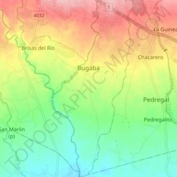
Name: Bugába topographic map, elevation, terrain.
Location: Bugába, Distrito Bugaba, Chiriquí, Panamá (8.44801 -82.64308 8.51066 -82.60498)
Average elevation: 137 m
Minimum elevation: 76 m
Maximum elevation: 215 m
Thank you for supporting this site ❤️
Make a donation
Make a donation
Other topographic maps
Click on a map to view its topography, its elevation and its terrain.