
Lunag Ri topographic map
Interactive map
Click on the map to display elevation.
About this map
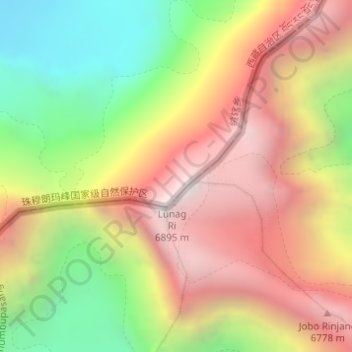
Name: Lunag Ri topographic map, elevation, terrain.
Location: Lunag Ri, Tingri, 日喀则市, Tibet, Chine (28.05354 86.55003 28.05364 86.55013)
Average elevation: 6,022 m
Minimum elevation: 5,094 m
Maximum elevation: 6,889 m
Other topographic maps
Click on a map to view its topography, its elevation and its terrain.