
Seginim topographic map
Click on the map to display elevation.
About this map
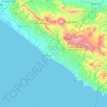
Name: Seginim topographic map, elevation, terrain.
Location: Seginim, Bengkulu, Sumatra, Indonesia (-5.13447 102.31524 -3.73447 103.71524)
Average elevation: 362 m
Minimum elevation: -1 m
Maximum elevation: 3,145 m
Other topographic maps
Click on a map to view its topography, its elevation and its terrain.
Bengkulu
Indonesia > Bengkulu > Teluk Segara
The region is at low elevation and can have swamps. In the mid-19th century, malaria and related diseases were common. Bengkulu lies near the Sunda Fault and is prone to earthquakes and tsunamis. The June 2000 Enggano earthquake killed at least 100 people. A recent report predicts that Bengkulu is "at risk of…
Average elevation: 6 m