
Düring topographic map
Interactive map
Click on the map to display elevation.
About this map
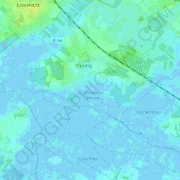
Name: Düring topographic map, elevation, terrain.
Location: Düring, Loxstedt, Landkreis Cuxhaven, Niedersachsen, Deutschland (53.42894 8.64219 53.47098 8.70347)
Average elevation: 2 m
Minimum elevation: -3 m
Maximum elevation: 13 m
Other topographic maps
Click on a map to view its topography, its elevation and its terrain.
Hahnenknoop
Deutschland > Niedersachsen > Loxstedt
Hahnenknoop, Loxstedt, Landkreis Cuxhaven, Niedersachsen, Deutschland
Average elevation: 3 m