
Lake Titicaca topographic map
Interactive map
Click on the map to display elevation.
About this map
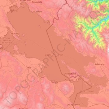
Name: Lake Titicaca topographic map, elevation, terrain.
Location: Lake Titicaca, Peru (-16.59816 -70.03591 -15.23369 -68.56834)
Average elevation: 3,869 m
Minimum elevation: 1,316 m
Maximum elevation: 5,797 m
Other topographic maps
Click on a map to view its topography, its elevation and its terrain.
San Miguel
Peru > Cusco > Machupicchu > Intihuatana
San Miguel, Intihuatana, Machupicchu, Province of Urubamba, Cusco, 08680, Peru
Average elevation: 2,262 m
La Merced de Chaute
La Merced de Chaute, San Bartolomé, Province of Huarochirí, Lima, Peru
Average elevation: 2,594 m
Santa Fe
Peru > Loreto > Emilio San Martín
Santa Fe, Emilio San Martín, Province of Requena, Loreto, Peru
Average elevation: 103 m
Province of Lima
Peru > Lima > Lima Metropolitan Area
Province of Lima, Lima Metropolitan Area, Lima, Peru
Average elevation: 1,234 m
Province of San Marcos
Province of San Marcos, Cajamarca, 06321, Peru
Average elevation: 2,783 m
Montevideo
Montevideo, Uranmarca, Province of Chincheros, Apurímac, Peru
Average elevation: 3,249 m
San Rafael
San Rafael, Province of Bellavista, San Martín, Peru
Average elevation: 268 m
Rosario
Rosario, Province of Acobamba, Huancavelica, Peru
Average elevation: 3,467 m
Buenos Aires
Buenos Aires, Province of Picota, San Martín, Peru
Average elevation: 450 m
Huancarani
Peru > Cusco > Huancarani
Huancarani, Province of Paucartambo, Cusco, Peru
Average elevation: 3,854 m
Laguna Palococha
Laguna Palococha, AN-110, Ticapampa, Recuay, Ancash, Peru
Average elevation: 3,765 m
Micaela Bastidas
Peru > Arequipa > Micaela Bastidas
Micaela Bastidas, Arequipa, 0154, Peru
Average elevation: 2,198 m
Machupicchu
Peru > Cusco > Machupicchu
Machupicchu, Province of Urubamba, Cusco, Peru
Average elevation: 3,640 m
Fundo La Esperanza
Peru > Ica > Fundo La Esperanza
Fundo La Esperanza, Pisco, Ica, Peru
Average elevation: 245 m
Pueblo Libre
Pueblo Libre, Province of Lima, Lima Metropolitan Area, Lima, Peru
Average elevation: 83 m
Pueblo Libre
Peru > San Martín > Pueblo Libre
Pueblo Libre, Moyobamba, San Martín, Peru
Average elevation: 842 m
Ciudad Satélite
Peru > Junín > Ciudad Satélite
Ciudad Satélite, Province of Satipo, Junín, Peru
Average elevation: 768 m
Independencia
Peru > Lima > Independencia
Independencia, Province of Lima, Lima, Peru
Average elevation: 224 m
Ollantaytambo
Peru > Cusco > Ollantaytambo
Ollantaytambo, Province of Urubamba, Cusco, 08676, Peru
Average elevation: 3,929 m
Province of Huaylas
Peru > Ancash > Santa Cruz
Province of Huaylas, Santa Cruz, Huaylas, Ancash, Peru
Average elevation: 2,353 m
Cochabamba
Peru > Apurímac > Cochabamba
Cochabamba, Chincheros, Apurímac, Peru
Average elevation: 3,578 m
Province of San Marcos
Peru > Cajamarca > José Sabogal
Province of San Marcos, José Sabogal, San Marcos, Cajamarca, Peru
Average elevation: 3,865 m