
Thank you for supporting this site ❤️
Make a donation
Make a donation
Bangna topographic map
Click on the map to display elevation.
Thank you for supporting this site ❤️
Make a donation
Make a donation
About this map
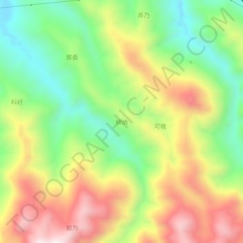
Name: Bangna topographic map, elevation, terrain.
Location: Bangna, Baise, Guangxi, China (24.70080 105.51400 24.74080 105.55400)
Average elevation: 901 m
Minimum elevation: 583 m
Maximum elevation: 1,289 m
Thank you for supporting this site ❤️
Make a donation
Make a donation
Other topographic maps
Click on a map to view its topography, its elevation and its terrain.