
Thank you for supporting this site ❤️
Make a donation
Make a donation
Saint-Joseph-de-Coleraine topographic map
Click on the map to display elevation.
Thank you for supporting this site ❤️
Make a donation
Make a donation
About this map
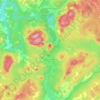
Name: Saint-Joseph-de-Coleraine topographic map, elevation, terrain.
Average elevation: 329 m
Minimum elevation: 179 m
Maximum elevation: 549 m
Thank you for supporting this site ❤️
Make a donation
Make a donation
Other topographic maps
Click on a map to view its topography, its elevation and its terrain.
Beaulac-Garthby
Canada > Quebec > Les Appalaches > Beaulac-Garthby > Beaulac-Garthby
Average elevation: 268 m
Thank you for supporting this site ❤️
Make a donation
Make a donation