
Make a donation
Suthep topographic map
Click on the map to display elevation.
Make a donation
About this map
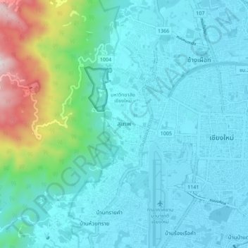
Name: Suthep topographic map, elevation, terrain.
Average elevation: 450 m
Minimum elevation: 300 m
Maximum elevation: 1,235 m
Make a donation
Other topographic maps
Click on a map to view its topography, its elevation and its terrain.
Chiang Mai City Municipality
The city is situated in a broad basin in the Thai highlands and lies at an average elevation of 300 m (1,000 ft) elevation above sea level. Chiang Mai's city centre sits west of the Ping River, a tributary to the Chao Phraya River. The city's sprawl extends outward in all directions, especially north, south,…
Average elevation: 325 m
Chiang Mai City Municipality
The city is situated in a valley on a river basin in the Thai highlands and is on average at 300 m (1,000 ft) elevation. Chiang Mai's city centre sits west of the Ping River, a tributary to the Chao Phraya River, while the city's sprawl extends north-west, south-west, north-east and east of the river. To the…
Average elevation: 325 m