
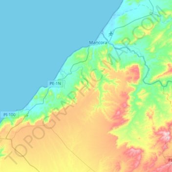
Los Órganos topographic map
Interactive map
Click on the map to display elevation.
About this map
Name: Los Órganos topographic map, elevation, terrain.
Location: Los Órganos, Provincia de Talara, Piura, Perú (-4.22706 -81.20216 -4.12805 -80.90893)
Average elevation: 140 m
Minimum elevation: -11 m
Maximum elevation: 530 m
Other topographic maps
Click on a map to view its topography, its elevation and its terrain.
Los Organos
Perú > Piura > Los Órganos
Los Organos, Los Órganos, Talara, Piura, 20840, Perú
Average elevation: 38 m
Vichayito
Perú > Piura > Los Órganos
Vichayito, Los Órganos, Talara, Piura, 20840, Perú
Average elevation: 17 m