
Parc National de Gouraya topographic map
Interactive map
Click on the map to display elevation.
About this map
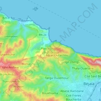
Name: Parc National de Gouraya topographic map, elevation, terrain.
Average elevation: 125 m
Minimum elevation: -1 m
Maximum elevation: 633 m
Other topographic maps
Click on a map to view its topography, its elevation and its terrain.
Pic des singes
Pic des singes, Amimoune أميمون, Béjaïa, Daïra Béjaïa, Béjaïa, 06000, RADP
Average elevation: 123 m