
Lubero topographic map
Interactive map
Click on the map to display elevation.
About this map
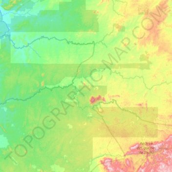
Name: Lubero topographic map, elevation, terrain.
Location: Lubero, North Kivu, Democratic Republic of the Congo (-0.17103 28.12988 -0.00499 28.87016)
Average elevation: 979 m
Minimum elevation: 661 m
Maximum elevation: 1,813 m
Other topographic maps
Click on a map to view its topography, its elevation and its terrain.
Mulo
Democratic Republic of the Congo > North Kivu > Lubero
Mulo, Baswaga, Lubero, North Kivu, Democratic Republic of the Congo
Average elevation: 1,964 m
Mambia
Democratic Republic of the Congo > North Kivu > Lubero > Mambia
Mambia, Baswaga, Lubero, North Kivu, Democratic Republic of the Congo
Average elevation: 1,191 m
Lake Edward
Democratic Republic of the Congo > North Kivu > Lubero
Lake Edward, Lubero, North Kivu, Democratic Republic of the Congo
Average elevation: 1,132 m