
Make a donation
Hofsgrund topographic map
Click on the map to display elevation.
Make a donation
Hofsgrund
Hofsgrund ist ein Ortsteil von Oberried und hat etwa 580 Einwohner. Er ist ein Ferien- und Wintersportort und Ziel von Ausflügen. Er liegt auf 1032 bis 1056 m Höhe südlich des Schauinslandgipfels.
Make a donation
About this map
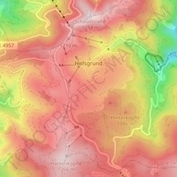
Name: Hofsgrund topographic map, elevation, terrain.
Average elevation: 1,058 m
Minimum elevation: 670 m
Maximum elevation: 1,279 m
Make a donation
Other topographic maps
Click on a map to view its topography, its elevation and its terrain.
Hochstetten
Deutschland > Baden-Württemberg > Landkreis Breisgau-Hochschwarzwald > Breisach am Rhein
Average elevation: 193 m
Möhlintal
Deutschland > Baden-Württemberg > Landkreis Breisgau-Hochschwarzwald > St. Ulrich
Average elevation: 649 m
Stohren
Deutschland > Baden-Württemberg > Landkreis Breisgau-Hochschwarzwald > Münstertal > Gießhübel
Average elevation: 1,013 m
Make a donation