Geolocate

Savona topographic map

Click on the map to display elevation.

About this map

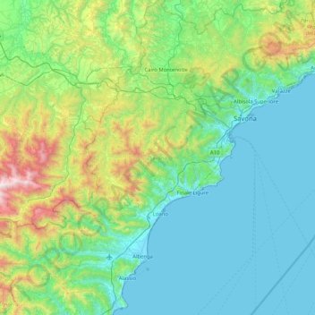
Name: Savona topographic map, elevation, terrain.

Location: Savona, Liguria, Italy (43.93824 7.97728 44.52855 8.67092)

Average elevation: 415 m

Minimum elevation: -1 m

Maximum elevation: 2,232 m

Other topographic maps

Click on a map to view its topography, its elevation and its terrain.

Ferriera

Italy > Liguria > Genoa > Arenzano

Ferriera, Pineta di Arenzano, Arenzano, Genoa, Liguria, 16011, Italy

Average elevation: 47 m

Sestri Levante

Italy > Liguria

Sestri Levante, Genoa, Liguria, Italy

Average elevation: 114 m

Medio Ponente

Italy > Liguria > Genoa

Medio Ponente, Genoa, Liguria, Italy

Average elevation: 160 m

Genoa

Italy > Liguria

Genoa, Liguria, Italy

Average elevation: 333 m

Savona

Italy > Liguria

Savona, SV, Liguria, 17100, Italy

Average elevation: 163 m

Genoa

Italy > Liguria

Genoa, Liguria, Italy

Average elevation: 388 m

Liguria

Italy

Liguria, Italy

Average elevation: 261 m

In order to remain free and to keep improving, this site uses cookies created by Google to compile visit statistics and display personalized advertisements.

How is the collected data used?