
Thank you for supporting this site ❤️
Make a donation
Make a donation
Rainham topographic map
Click on the map to display elevation.
Thank you for supporting this site ❤️
Make a donation
Make a donation
About this map
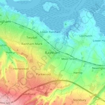
Name: Rainham topographic map, elevation, terrain.
Location: Rainham, Kent, England, ME8 7JJ, United Kingdom (51.32331 0.56836 51.40331 0.64836)
Average elevation: 52 m
Minimum elevation: -2 m
Maximum elevation: 176 m
Thank you for supporting this site ❤️
Make a donation
Make a donation
Other topographic maps
Click on a map to view its topography, its elevation and its terrain.
Thank you for supporting this site ❤️
Make a donation
Make a donation
Thank you for supporting this site ❤️
Make a donation
Make a donation