
Thank you for supporting this site ❤️
Make a donation
Make a donation
Henderson topographic map
Click on the map to display elevation.
Thank you for supporting this site ❤️
Make a donation
Make a donation
About this map
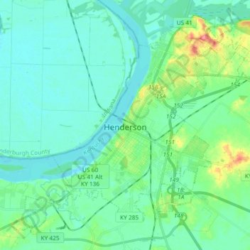
Name: Henderson topographic map, elevation, terrain.
Location: Henderson, Henderson County, Kentucky, United States (37.79103 -87.65925 37.89237 -87.51354)
Average elevation: 118 m
Minimum elevation: 104 m
Maximum elevation: 171 m
Thank you for supporting this site ❤️
Make a donation
Make a donation
Other topographic maps
Click on a map to view its topography, its elevation and its terrain.