
Make a donation
Smithfield Township topographic map
Click on the map to display elevation.
Make a donation
About this map
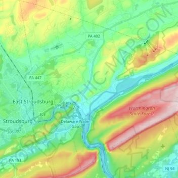
Name: Smithfield Township topographic map, elevation, terrain.
Average elevation: 211 m
Minimum elevation: 82 m
Maximum elevation: 481 m
Make a donation
Other topographic maps
Click on a map to view its topography, its elevation and its terrain.
Otter Lake
United States > Pennsylvania > Monroe County > Middle Smithfield Township
Average elevation: 353 m
Camelback Mountain
United States > Pennsylvania > Monroe County > Jackson Township
Average elevation: 458 m
Kalahari Indoor Waterpark
United States > Pennsylvania > Monroe County > Tobyhanna Township
Average elevation: 553 m
Make a donation
Great Wolf Lodge Water Park
United States > Pennsylvania > Monroe County > Pocono Township > Scotrun
Average elevation: 354 m
Buck Hill Falls
United States > Pennsylvania > Monroe County > Barrett Township > Mountainhome
Average elevation: 380 m
Camelot Forest
United States > Pennsylvania > Monroe County > Tobyhanna Township
Average elevation: 514 m
Make a donation
Pinecrest Lake
United States > Pennsylvania > Monroe County > Tobyhanna Township
Average elevation: 556 m