
Thank you for supporting this site ❤️
Make a donation
Make a donation
Hann. Münden topographic map
Click on the map to display elevation.
Thank you for supporting this site ❤️
Make a donation
Make a donation
About this map
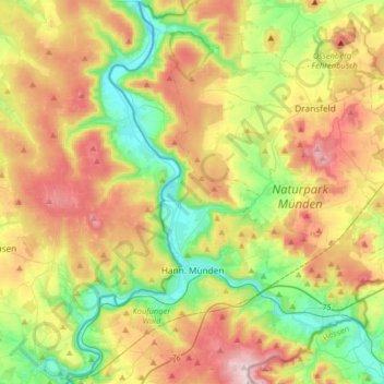
Name: Hann. Münden topographic map, elevation, terrain.
Location: Hann. Münden, Landkreis Göttingen, Lower Saxony, 34346, Germany (51.35638 9.56846 51.55769 9.80253)
Average elevation: 287 m
Minimum elevation: 108 m
Maximum elevation: 538 m
Thank you for supporting this site ❤️
Make a donation
Make a donation
Other topographic maps
Click on a map to view its topography, its elevation and its terrain.
Kamschlacken
Germany > Lower Saxony > Landkreis Göttingen > Osterode am Harz > Riefensbeek-Kamschlacken
Average elevation: 513 m
Thank you for supporting this site ❤️
Make a donation
Make a donation
Zoll
Germany > Lower Saxony > Landkreis Göttingen > Bad Lauterberg im Harz > Barbis
Average elevation: 315 m