
Kyllini (Ziria) topographic map
Interactive map
Click on the map to display elevation.
About this map
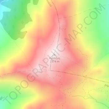
Name: Kyllini (Ziria) topographic map, elevation, terrain.
Average elevation: 1,994 m
Minimum elevation: 1,474 m
Maximum elevation: 2,368 m
Other topographic maps
Click on a map to view its topography, its elevation and its terrain.
Community of Ano Trikala
Greece > Peloponnese, Western Greece and the Ionian > Corinthia Regional Unit > Municipal Unit of Xylokastro
Community of Ano Trikala, Municipal Unit of Xylokastro, Municipality of Xylokastro and Evrostina, Corinthia Regional Unit, Peloponnese Region, Peloponnese, Western Greece and the Ionian, Greece
Average elevation: 1,551 m