
Thank you for supporting this site ❤️
Make a donation
Make a donation
Waldprechting topographic map
Click on the map to display elevation.
Thank you for supporting this site ❤️
Make a donation
Make a donation
About this map
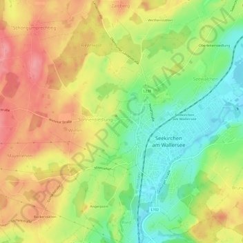
Name: Waldprechting topographic map, elevation, terrain.
Average elevation: 552 m
Minimum elevation: 503 m
Maximum elevation: 600 m
Thank you for supporting this site ❤️
Make a donation
Make a donation
Other topographic maps
Click on a map to view its topography, its elevation and its terrain.
Wallersee
Österreich > Salzburg > Bezirk Salzburg-Umgebung > Seekirchen am Wallersee > Fischtaging
Der See liegt heute auf 505 m Seehöhe und hat eine Ausdehnung von 6,4 km².
Average elevation: 531 m