
Make a donation
Clementon topographic map
Click on the map to display elevation.
Make a donation
About this map
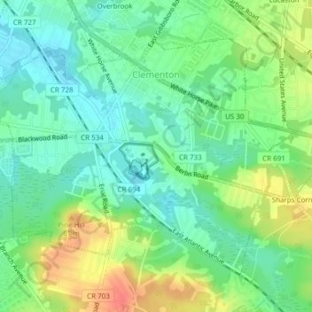
Name: Clementon topographic map, elevation, terrain.
Location: Clementon, Camden County, New Jersey, United States (39.79287 -75.00367 39.81491 -74.96584)
Average elevation: 31 m
Minimum elevation: 12 m
Maximum elevation: 62 m
Make a donation
Other topographic maps
Click on a map to view its topography, its elevation and its terrain.
Cooper River Lake
United States > New Jersey > Camden County > Cherry Hill Township > Stoys Landing
Average elevation: 10 m
Make a donation
Make a donation
Locust Grove
United States > New Jersey > Camden County > Cherry Hill Township
Average elevation: 25 m
Stoys Landing
United States > New Jersey > Camden County > Cherry Hill Township
Average elevation: 14 m
Make a donation
Make a donation
Make a donation
Haddon
United States > New Jersey > Camden County
In 1890, Benjamin A. Lippincott constructed a passenger station in the center of his land for the Atlantic City Railroad. Then Lippincott, with Charles Hillman, filed a grid street plan with Camden County to develop a community. They named it Haddon Heights because of its proximity to Haddonfield and its high…
Average elevation: 9 m
Make a donation