
Thank you for supporting this site ❤️
Make a donation
Make a donation
Stenhamra topographic map
Click on the map to display elevation.
Thank you for supporting this site ❤️
Make a donation
Make a donation
About this map
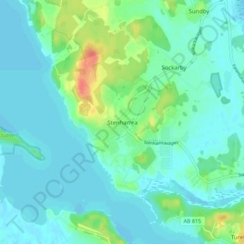
Name: Stenhamra topographic map, elevation, terrain.
Location: Stenhamra, Ekerö kommun, Stockholms län, 179 65, Sverige (59.31475 17.66736 59.35475 17.70736)
Average elevation: 10 m
Minimum elevation: -4 m
Maximum elevation: 48 m
Thank you for supporting this site ❤️
Make a donation
Make a donation
Other topographic maps
Click on a map to view its topography, its elevation and its terrain.