
Thank you for supporting this site ❤️
Make a donation
Make a donation
Charron topographic map
Click on the map to display elevation.
Thank you for supporting this site ❤️
Make a donation
Make a donation
About this map
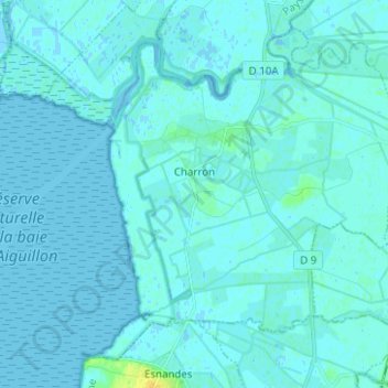
Name: Charron topographic map, elevation, terrain.
Average elevation: 2 m
Minimum elevation: -2 m
Maximum elevation: 17 m
Thank you for supporting this site ❤️
Make a donation
Make a donation
Other topographic maps
Click on a map to view its topography, its elevation and its terrain.
Roumette
Frankrijk > Nieuw-Aquitanië > Charente-Maritime > Saint-Bris-des-Bois
Average elevation: 76 m
La Basse Coudre
Frankrijk > Nieuw-Aquitanië > Charente-Maritime > Tonnay-Charente
Average elevation: 4 m
Thank you for supporting this site ❤️
Make a donation
Make a donation
Lavaud
Frankrijk > Nieuw-Aquitanië > Charente-Maritime > Réaux-sur-Trèfle > Lavaud
Average elevation: 44 m
L'Île d'Albe
Frankrijk > Nieuw-Aquitanië > Charente-Maritime > Muron > L'Île d'Albe
Average elevation: 3 m
Thank you for supporting this site ❤️
Make a donation
Make a donation