
Thank you for supporting this site ❤️
Make a donation
Make a donation
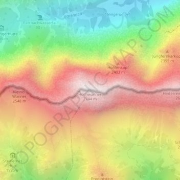
Hochwanner topographic map
Click on the map to display elevation.
Thank you for supporting this site ❤️
Make a donation
Make a donation
Hochwanner
Der Hochwanner (veraltet: Kothbachspitze) ist ein Berg im Wettersteingebirge. Er ist mit 2744 m ü. NHN der nach der Zugspitze zweithöchste Berg Deutschlands (sofern man den noch höheren Schneefernerkopf und die ebenfalls geringfügig höheren Wetterspitzen nur als Nebengipfel der Zugspitze betrachtet).
Thank you for supporting this site ❤️
Make a donation
Make a donation
About this map
Name: Hochwanner topographic map, elevation, terrain.
Location: Hochwanner, Leutasch, Bezirk Innsbruck-Land, Tirol, Österreich (47.39591 11.05531 47.39601 11.05541)
Average elevation: 1,968 m
Minimum elevation: 1,188 m
Maximum elevation: 2,723 m
Thank you for supporting this site ❤️
Make a donation
Make a donation
Other topographic maps
Click on a map to view its topography, its elevation and its terrain.