
Thank you for supporting this site ❤️
Make a donation
Make a donation
Eine topographic map
Click on the map to display elevation.
Thank you for supporting this site ❤️
Make a donation
Make a donation
About this map
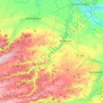
Name: Eine topographic map, elevation, terrain.
Location: Eine, Mansfeld-Südharz, Saxony-Anhalt, Germany (51.60758 11.25233 51.75639 11.51112)
Average elevation: 221 m
Minimum elevation: 94 m
Maximum elevation: 374 m
Thank you for supporting this site ❤️
Make a donation
Make a donation
Other topographic maps
Click on a map to view its topography, its elevation and its terrain.