
Long Thành District topographic map
Interactive map
Click on the map to display elevation.
About this map
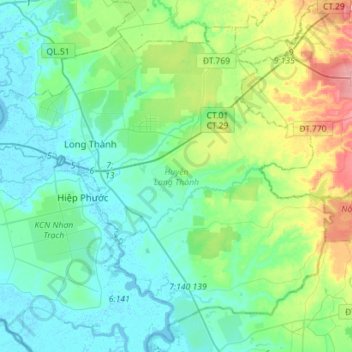
Name: Long Thành District topographic map, elevation, terrain.
Location: Long Thành District, Đồng Nai Province, 76009, Vietnam (10.64365 106.86427 10.87906 107.14637)
Average elevation: 42 m
Minimum elevation: -4 m
Maximum elevation: 190 m
Other topographic maps
Click on a map to view its topography, its elevation and its terrain.
Bien Hoa
Vietnam > Dong Nai province > Bien Hoa
Bien Hoa, Bien Hoa City, Dong Nai province, 81000, Vietnam
Average elevation: 24 m