
Make a donation
Milina topographic map
Click on the map to display elevation.
Make a donation
About this map
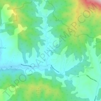
Name: Milina topographic map, elevation, terrain.
Average elevation: 294 m
Minimum elevation: 168 m
Maximum elevation: 651 m
Make a donation
Other topographic maps
Click on a map to view its topography, its elevation and its terrain.
Donja Badanja
Serbia > Central Serbia > Macva Administrative District
Donja Badanja is a village located at the base of the mountain Cer and the low mountain Iverak, in the Jadar region. The Cernica River runs through Donja Badanja. The altitude of Donja Badanja is 180 -m-. Donja Badanja is connected by motorway to Šabac and Loznica, and further by highway to Belgrade. Donja…
Average elevation: 191 m
Make a donation
Mrovska
Serbia > Central Serbia > Macva Administrative District > Vladimirci Municipality
Average elevation: 182 m
Bogatic
Serbia > Central Serbia > Macva Administrative District > Bogatic Municipality
Average elevation: 84 m
Думача
Serbia > Central Serbia > Macva Administrative District > Gornja Vranjska
Average elevation: 107 m
Make a donation
Ljubovija Municipality
Serbia > Central Serbia > Macva Administrative District
Average elevation: 535 m
Ljubovija Municipality
Serbia > Central Serbia > Macva Administrative District > Ljubovija Municipality
Average elevation: 535 m
Make a donation