
Make a donation
Großmonra topographic map
Click on the map to display elevation.
Make a donation
Großmonra
Stadtteil: Kiebitzhöhe
Make a donation
About this map
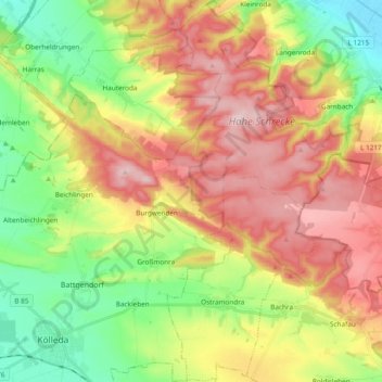
Name: Großmonra topographic map, elevation, terrain.
Location: Großmonra, Kölleda, Landkreis Sömmerda, Thüringen, Deutschland (51.17493 11.26335 51.29366 11.39115)
Average elevation: 240 m
Minimum elevation: 115 m
Maximum elevation: 384 m
Make a donation
Other topographic maps
Click on a map to view its topography, its elevation and its terrain.
Dermsdorf
Deutschland > Thüringen > Landkreis Sömmerda > Kölleda
Im Jahr 2011 gab es den archäologisch bedeutenden Depotfund von Dermsdorf: Beim Bau der Ortsumgehung fand man auf einer Fläche von 7000 m² Pfosten, Abfallgruben und Gräber der frühen Bronzezeit (ca. 2000–1700 v. Chr.) und aus dem Mittelalter (8.–11. Jahrhundert). Herausragend war dabei ein Depot von…
Average elevation: 152 m
Burgwenden
Deutschland > Thüringen > Landkreis Sömmerda > Kölleda
Burgwenden liegt eingebettet zwischen den Höhenzügen Monraburg, Wendenburg (354 m) und Finnberg am südlichen Ausgang eines Passes durch die Schmücke und Hohe Schrecke. Durch den Ort verläuft der Hirschbach.
Average elevation: 264 m