
Nea Peramos topographic map
Interactive map
Click on the map to display elevation.
About this map
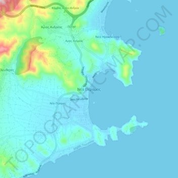
Name: Nea Peramos topographic map, elevation, terrain.
Average elevation: 41 m
Minimum elevation: -1 m
Maximum elevation: 388 m
Other topographic maps
Click on a map to view its topography, its elevation and its terrain.
Kavala
Greece > Macedonia and Thrace > Kavala Regional Unit
Kavala, Kavala Prefecture, Kavala Regional Unit, Eastern Macedonia and Thrace, Macedonia and Thrace, 653 02, Greece
Average elevation: 173 m