
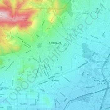
Municipal Unit of Nikaia topographic map
Interactive map
Click on the map to display elevation.
About this map
Name: Municipal Unit of Nikaia topographic map, elevation, terrain.
Average elevation: 95 m
Minimum elevation: 5 m
Maximum elevation: 458 m
Other topographic maps
Click on a map to view its topography, its elevation and its terrain.
Λιμένας Λέοντος
Greece > Attica > Regional Unit of Piraeus > Piraeus > Δραπετσώνα
Λιμένας Λέοντος, Δραπετσώνα, Piraeus, Regional Unit of Piraeus, Attica, Greece
Average elevation: 12 m
Piraeus
Greece > Attica > Regional Unit of Piraeus
Piraeus, Municipality of Piraeus, Regional Unit of Piraeus, Attica, 185 35, Greece
Average elevation: 96 m