
Dumaguete topographic map
Interactive map
Click on the map to display elevation.
About this map
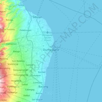
Name: Dumaguete topographic map, elevation, terrain.
Location: Dumaguete, Negros Oriental, Central Visayas, 6200, Philippines (9.27093 123.25178 9.33511 123.42084)
Average elevation: 55 m
Minimum elevation: 0 m
Maximum elevation: 500 m
As a coastal city, it is bounded on the east by the Bohol Sea and the Tañon Strait, serving as a natural border of southeastern Negros Island Region to the neighboring Central Visayas. The city's topography is generally flat from two to six kilometers from the shoreline. It slopes gently upwards to the adjoining municipality of Valencia. The highest ground elevation is located at the boundary of the municipality of Valencia, about one hundred meters above mean sea level. About 93% of the land have slopes of less than 3%. The remaining areas have 3% to 5% slope.
Other topographic maps
Click on a map to view its topography, its elevation and its terrain.
Omol
Philippines > Negros Oriental > Santa Catalina
Omol, Santa Catalina, Negros Oriental, Central Visayas, Philippines
Average elevation: 224 m
Talamban
Philippines > Negros Oriental > Jimalalud
Talamban, Jimalalud, Negros Oriental, Central Visayas, 6211, Philippines
Average elevation: 253 m
East Balabag
Philippines > Negros Oriental > Valencia
East Balabag, Valencia, Negros Oriental, Central Visayas, Philippines
Average elevation: 141 m
Mansagomayon
Philippines > Negros Oriental > Santa Catalina
Mansagomayon, Santa Catalina, Negros Oriental, Central Visayas, Philippines
Average elevation: 195 m
Obat
Philippines > Negros Oriental > Santa Catalina
Obat, Santa Catalina, Negros Oriental, Central Visayas, Philippines
Average elevation: 118 m
Dawis
Dawis, Negros Oriental, Central Visayas, Philippines
Average elevation: 276 m
La Paz
Philippines > Negros Oriental > Bais
La Paz, Bais, Negros Oriental, Central Visayas, 6206, Philippines
Average elevation: 14 m
Piapi
Philippines > Negros Oriental > Dumaguete
Piapi, Dumaguete, Negros Oriental, Central Visayas, Philippines
Average elevation: 10 m
Tanjay
Tanjay, Negros Oriental, Central Visayas, 6204, Philippines
Average elevation: 172 m
Manjuyod
Manjuyod, Negros Oriental, Central Visayas, Philippines
Average elevation: 72 m
Jilocon
Jilocon, Negros Oriental, Central Visayas, 6202, Philippines
Average elevation: 37 m
Canlaon
Philippines > Negros Oriental > Canlaon
Canlaon, Negros Oriental, Central Visayas, 6223, Philippines
Average elevation: 432 m
Sibulan
Philippines > Negros Oriental > Sibulan
Sibulan, Negros Oriental, Central Visayas, 6201, Philippines
Average elevation: 22 m
Dumaguete
Philippines > Negros Oriental > Dumaguete
Dumaguete, Negros Oriental, Central Visayas, 6200, Philippines
Average elevation: 167 m
Bayawan
Bayawan, Negros Oriental, Central Visayas, 6221, Philippines
Average elevation: 226 m
Mabinay
Philippines > Negros Oriental > Mabinay
Mabinay, Negros Oriental, Central Visayas, Philippines
Average elevation: 146 m
Mt. Cuernos de Negros (Talinis)
Philippines > Negros Oriental > Dumaguete
Mt. Cuernos de Negros (Talinis), Dumaguete, Negros Oriental, Central Visayas, Philippines
Average elevation: 1,479 m