
Erftstadt topographic map
Interactive map
Click on the map to display elevation.
About this map
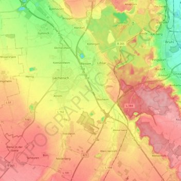
Name: Erftstadt topographic map, elevation, terrain.
Average elevation: 119 m
Minimum elevation: 52 m
Maximum elevation: 168 m
Other topographic maps
Click on a map to view its topography, its elevation and its terrain.
Blessem
Allemagne > Rhénanie-du-Nord-Westphalie > Erftstadt > Blessem
Blessem, Erftstadt, Rhein-Erft-Kreis, Rhénanie-du-Nord-Westphalie, 50374, Allemagne
Average elevation: 100 m