
Thank you for supporting this site ❤️
Make a donation
Make a donation
Lürbke topographic map
Click on the map to display elevation.
Thank you for supporting this site ❤️
Make a donation
Make a donation
About this map
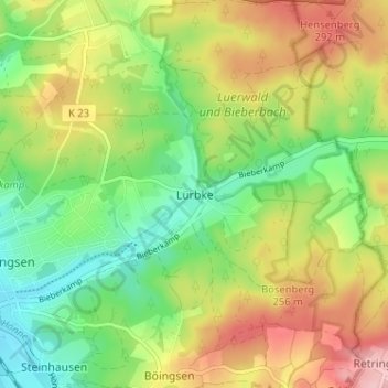
Name: Lürbke topographic map, elevation, terrain.
Average elevation: 229 m
Minimum elevation: 156 m
Maximum elevation: 325 m
Thank you for supporting this site ❤️
Make a donation
Make a donation
Other topographic maps
Click on a map to view its topography, its elevation and its terrain.
58708
Deutschland > Nordrhein-Westfalen > Märkischer Kreis > Menden (Sauerland) > Oberoesbern
Average elevation: 222 m
58710
Deutschland > Nordrhein-Westfalen > Märkischer Kreis > Menden (Sauerland)
Average elevation: 206 m