
Haora topographic map
Interactive map
Click on the map to display elevation.
About this map
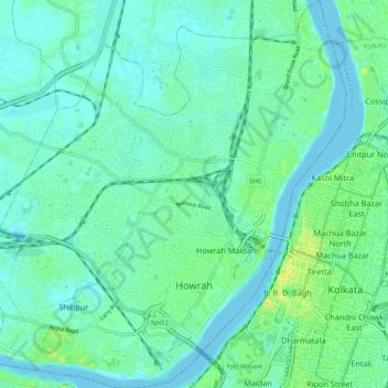
Name: Haora topographic map, elevation, terrain.
Location: Haora, Howrah District, West-Bengalen, India (22.54928 88.26907 22.64111 88.36409)
Average elevation: 6 m
Minimum elevation: -1 m
Maximum elevation: 24 m
Other topographic maps
Click on a map to view its topography, its elevation and its terrain.
Rampurhat - I
India > West-Bengalen > Rampurhat - I
Rampurhat - I, Birbhum, West-Bengalen, India
Average elevation: 42 m
Darjeeling
India > West-Bengalen > Darjeeling Pulbazar
Darjeeling, Darjeeling Pulbazar, Darjeeling District, West-Bengalen, 734101, India
Average elevation: 1,324 m
Howrah
India > West-Bengalen > Haora > Howrah
Howrah, Haora, Howrah, West-Bengalen, 711101, India
Average elevation: 5 m
Koch Bihār
Koch Bihār, Kochbihar, West-Bengalen, 736134, India
Average elevation: 116 m
Naksalbari
India > West-Bengalen > Naksalbari
Naksalbari, Darjiling, Darjeeling, West-Bengalen, 734429, India
Average elevation: 154 m
বাগডোগরা
India > West-Bengalen > বাগডোগরা
বাগডোগরা, Darjiling, Darjeeling, West-Bengalen, India
Average elevation: 136 m
Neora Valley National Park
Neora Valley National Park, Kalimpong, West-Bengalen, India
Average elevation: 1,309 m