
Thank you for supporting this site ❤️
Make a donation
Make a donation
Grand-Métis topographic map
Click on the map to display elevation.
Thank you for supporting this site ❤️
Make a donation
Make a donation
About this map
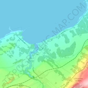
Name: Grand-Métis topographic map, elevation, terrain.
Location: Grand-Métis, La Mitis, Bas-Saint-Laurent, Québec, Canada (48.59407 -68.14067 48.66629 -68.04199)
Average elevation: 61 m
Minimum elevation: -4 m
Maximum elevation: 221 m
Thank you for supporting this site ❤️
Make a donation
Make a donation
Other topographic maps
Click on a map to view its topography, its elevation and its terrain.