
Thank you for supporting this site ❤️
Make a donation
Make a donation
Andenelle topographic map
Click on the map to display elevation.
Thank you for supporting this site ❤️
Make a donation
Make a donation
About this map
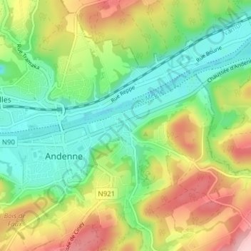
Name: Andenelle topographic map, elevation, terrain.
Location: Andenelle, Andenne, Namur, Wallonie, 5300, Belgique (50.47427 5.09197 50.51427 5.13197)
Average elevation: 132 m
Minimum elevation: 62 m
Maximum elevation: 243 m
Thank you for supporting this site ❤️
Make a donation
Make a donation
Other topographic maps
Click on a map to view its topography, its elevation and its terrain.
Thank you for supporting this site ❤️
Make a donation
Make a donation