
Thank you for supporting this site ❤️
Make a donation
Make a donation
Straumgjerde topographic map
Click on the map to display elevation.
Thank you for supporting this site ❤️
Make a donation
Make a donation
About this map
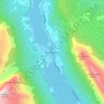
Name: Straumgjerde topographic map, elevation, terrain.
Location: Straumgjerde, Sykkylven, Møre og Romsdal, 6220, Norvège (62.31320 6.57363 62.35320 6.61363)
Average elevation: 302 m
Minimum elevation: -9 m
Maximum elevation: 1,201 m
Thank you for supporting this site ❤️
Make a donation
Make a donation
Other topographic maps
Click on a map to view its topography, its elevation and its terrain.