
Thank you for supporting this site ❤️
Make a donation
Make a donation
Swanton topographic map
Click on the map to display elevation.
Thank you for supporting this site ❤️
Make a donation
Make a donation
About this map
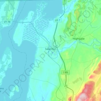
Name: Swanton topographic map, elevation, terrain.
Location: Swanton, Franklin County, Vermont, 05488, United States (44.81600 -73.24094 45.01382 -72.98914)
Average elevation: 66 m
Minimum elevation: 26 m
Maximum elevation: 355 m
Thank you for supporting this site ❤️
Make a donation
Make a donation
Other topographic maps
Click on a map to view its topography, its elevation and its terrain.
Thank you for supporting this site ❤️
Make a donation
Make a donation
Enosburg Center
United States > Vermont > Franklin County > Enosburg > Enosburg Center
Average elevation: 231 m
Thank you for supporting this site ❤️
Make a donation
Make a donation