
Southern Red Sea Zone topographic map
Interactive map
Click on the map to display elevation.
About this map
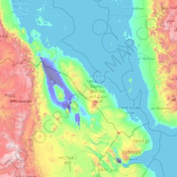
Name: Southern Red Sea Zone topographic map, elevation, terrain.
Location: Southern Red Sea Zone, Eritrea (11.15000 38.90000 16.35000 44.10000)
Average elevation: 604 m
Minimum elevation: -154 m
Maximum elevation: 4,088 m
Other topographic maps
Click on a map to view its topography, its elevation and its terrain.
Assab
Eritrea > Southern Red Sea Region > Assab
Assab, Southern Red Sea Region, Eritrea
Average elevation: 9 m
Asmara
Eritrea > Maekel Region > Asmara
Asmara, Maekel Region, 00291, Eritrea
Average elevation: 2,037 m
Assab
Eritrea > Southern Red Sea Region > Assab
Assab, Southern Red Sea Region, Eritrea
Average elevation: 24 m