
Thank you for supporting this site ❤️
Make a donation
Make a donation
Le Biolley topographic map
Click on the map to display elevation.
Thank you for supporting this site ❤️
Make a donation
Make a donation
About this map
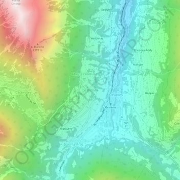
Name: Le Biolley topographic map, elevation, terrain.
Location: Le Biolley, Orsières, Entremont, Valais, 1937, Suisse (46.01111 7.11709 46.05111 7.15709)
Average elevation: 1,327 m
Minimum elevation: 808 m
Maximum elevation: 2,551 m
Thank you for supporting this site ❤️
Make a donation
Make a donation