
Thank you for supporting this site ❤️
Make a donation
Make a donation
Ain Radjeh topographic map
Click on the map to display elevation.
Thank you for supporting this site ❤️
Make a donation
Make a donation
About this map
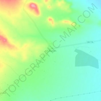
Name: Ain Radjeh topographic map, elevation, terrain.
Location: Ain Radjeh, Serghine, Ksar Chellala District, Tiaret, Algeria (35.25113 2.48968 35.29113 2.52968)
Average elevation: 767 m
Minimum elevation: 728 m
Maximum elevation: 839 m
Thank you for supporting this site ❤️
Make a donation
Make a donation
Other topographic maps
Click on a map to view its topography, its elevation and its terrain.