
Jabuguillo topographic map
Interactive map
Click on the map to display elevation.
About this map
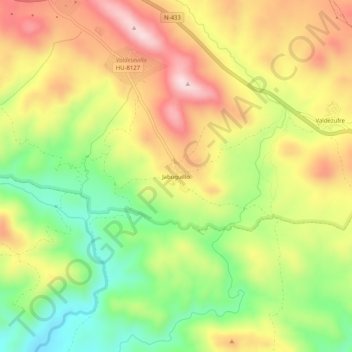
Name: Jabuguillo topographic map, elevation, terrain.
Average elevation: 560 m
Minimum elevation: 401 m
Maximum elevation: 721 m
Other topographic maps
Click on a map to view its topography, its elevation and its terrain.
Carboneras
España > Andalucía > Sierra de Aracena > Aracena
Carboneras, Aracena, Sierra de Aracena, Huelva, Andalucía, 21208, España
Average elevation: 567 m