
Les Beauvais topographic map
Interactive map
Click on the map to display elevation.
About this map
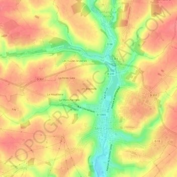
Name: Les Beauvais topographic map, elevation, terrain.
Average elevation: 134 m
Minimum elevation: 90 m
Maximum elevation: 159 m
Other topographic maps
Click on a map to view its topography, its elevation and its terrain.
L'Anillé
France > Pays de la Loire > Sarthe > Saint-Calais
L'Anillé, Saint-Calais, Mamers, Sarthe, Pays de la Loire, France métropolitaine, 72120, France
Average elevation: 141 m