
Thank you for supporting this site ❤️
Make a donation
Make a donation
Mapleton topographic map
Click on the map to display elevation.
Thank you for supporting this site ❤️
Make a donation
Make a donation
Mapleton
According to the United States Census Bureau, the city has a total area of 12.6 square miles (32.6 km2), all land. The community lies at an elevation of 4,700 feet (1,400 m) above sea level.
Thank you for supporting this site ❤️
Make a donation
Make a donation
About this map
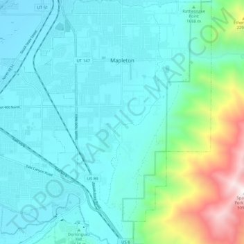
Name: Mapleton topographic map, elevation, terrain.
Location: Mapleton, Utah County, Utah, 84664, United States (40.07170 -111.61515 40.14929 -111.54153)
Average elevation: 1,682 m
Minimum elevation: 1,379 m
Maximum elevation: 3,084 m
Thank you for supporting this site ❤️
Make a donation
Make a donation
Other topographic maps
Click on a map to view its topography, its elevation and its terrain.
Thank you for supporting this site ❤️
Make a donation
Make a donation
Thank you for supporting this site ❤️
Make a donation
Make a donation
Thank you for supporting this site ❤️
Make a donation
Make a donation