
Thank you for supporting this site ❤️
Make a donation
Make a donation
Stuhlfelden topographic map
Click on the map to display elevation.
Thank you for supporting this site ❤️
Make a donation
Make a donation
About this map
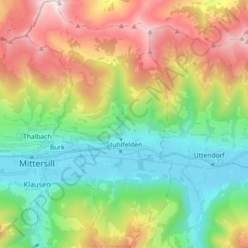
Name: Stuhlfelden topographic map, elevation, terrain.
Location: Stuhlfelden, Bezirk Zell am See, Salisburgo, 5724, Austria (47.25212 12.47831 47.33856 12.55327)
Average elevation: 1,347 m
Minimum elevation: 770 m
Maximum elevation: 2,333 m
Thank you for supporting this site ❤️
Make a donation
Make a donation
Other topographic maps
Click on a map to view its topography, its elevation and its terrain.