
Make a donation
Pasadena topographic map
Click on the map to display elevation.
Make a donation
Pasadena
Pasadena is located at 39°6′46″N 76°33′7″W / 39.11278°N 76.55194°W / 39.11278; -76.55194 (39.112809, −76.551871) in northern Anne Arundel County. It is bordered to the north by the city of Baltimore, to the east by the tidal Patapsco River and by Riviera Beach, to the southeast by Lake Shore, to the south by Severna Park, and to the west by Glen Burnie. The original community of Pasadena, shown on USGS topographic maps at the intersection of Pasadena Road and Governor Ritchie Highway (Maryland Route 2), is now assigned by the U.S. Census Bureau to the Severna Park census-designated place, south of the border for the Pasadena CDP, which itself is centered along Mountain Road (Maryland Route 177) and includes the neighborhoods of Ashburn and Green Haven, and extends north along the Marley Neck peninsula all the way to the Baltimore city line.
Make a donation
About this map
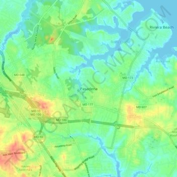
Name: Pasadena topographic map, elevation, terrain.
Average elevation: 16 m
Minimum elevation: -2 m
Maximum elevation: 46 m
Make a donation